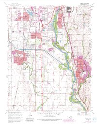
1960 Map of Derby
USGS Topo · Published 1983About this map
The Arkansas River corridor south of Wichita underwent significant suburban and industrial transformation during the mid-20th century, particularly around the growing communities of Derby and Haysville. The landscape is a complex intersection of traditional agricultural roots and modern infrastructure, evidenced by the presence of Waco Cem and Roll Cem near the newly established Kansas Turnpike. To the north, the massive footprint of Mc Connell Air Force Base and residential developments like Oaklawn and Riverside signal the region's mid-century expansion.
Find a feature on this map
47 named features on this map. Tap any name to fly to it.
Don’t see what you’re looking for? This feature index may not catch every label — zoom into the map to look around manually.
Map Details
Editions of this 1960 Derby Map
4 editions found
Other maps of this area

1889 · Wichita
USGS Topo · 1:125,000

1890 · Wellington
USGS Topo · 1:125,000

1894 · Wichita
USGS Topo · 1:125,000

1943 · Wichita West
USGS Topo · 1:31,680

1943 · Wichita East
USGS Topo · 1:31,680

1943 · Derby
USGS Topo · 1:31,680

1943 · Bayneville
USGS Topo · 1:31,680

1945 · Andover
USGS Topo · 1:31,680

1950 · Bayneville
USGS Topo · 1:24,000

1955 · Belle Plaine
USGS Topo · 1:24,000