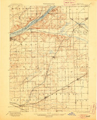
1901 Map of Des Plaines
USGS Topo · Published 1905About this map
The Chicago Sanitary and Ship Canal dominates the northern landscape of this turn-of-the-century survey, running parallel to the older Illinois and Michigan Canal and the Desplaines River. This corridor reflects a massive engineering era designed to manage regional water and commercial transport. To the south, the terrain transitions into a dense network of early townships including Orland, Bremen, and Frankfort, where agricultural land is segmented by an emerging rail infrastructure. Major lines like the Atchison Topeka and Santa Fe R. R. and the Chicago Rock Island and Pacific Railroad connect established stops at Lemont, Mokena, and Tinley Park. Small settlements and landmarks such as Gooding's Grove, Hadley, and Lane's Island provide critical markers for genealogists tracing late 19th-century homesteads and local commerce routes before the expansion of the Chicago metropolitan area.
Find a feature on this map
59 named features on this map. Tap any name to fly to it.
Don’t see what you’re looking for? This feature index may not catch every label — zoom into the map to look around manually.
Map Details
Editions of this 1901 Des Plaines Map
5 editions found

Other maps of this area

1889 · Chicago
USGS Topo · 1:62,500

1890 · Des Plaines
USGS Topo · 1:62,500

1891 · Chicago
USGS Topo · 1:62,500

1891 · Riverside
USGS Topo · 1:62,500

1892 · Joliet
USGS Topo · 1:62,500

1892 · Calumet
USGS Topo · 1:62,500

1892 · Wilmington
USGS Topo · 1:62,500

1893 · Calumet
USGS Topo · 1:62,500

1893 · Riverside
USGS Topo · 1:62,500

1894 · Des Plaines
USGS Topo · 1:62,500