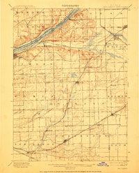
1901 Map of Des Plaines
USGS Topo · Published 1912About this map
The Chicago Sanitary and Ship Canal and the older Illinois and Michigan Canal parallel one another through the glacial valley of the Des Plaines River, highlighting a critical corridor of late-nineteenth-century engineering. This industrial backbone connects the quarries and settlements of Lemont and Sag Bridge to the broader Chicago terminal network. Away from the water, the landscape transitions into the rolling moraine of Mount Forest and the agricultural townships of Orland and Frankfort. Smaller, era-specific rail stops like Goeselville, Hadley, and Marley dot the prairie, serving as focal points for rural communities before the expansion of the modern Chicago suburbs. The extensive network of railroads, including the Chicago Terminal Transfer R. R. and the Chicago and St. Louis Line, illustrates the region's rapid transition from a waterway-dependent economy to a rail-dominated transportation hub.
Find a feature on this map
56 named features on this map. Tap any name to fly to it.
Don’t see what you’re looking for? This feature index may not catch every label — zoom into the map to look around manually.
Map Details
Editions of this 1901 Des Plaines Map
5 editions found

Other maps of this area

1889 · Chicago
USGS Topo · 1:62,500

1890 · Des Plaines
USGS Topo · 1:62,500

1891 · Chicago
USGS Topo · 1:62,500

1891 · Riverside
USGS Topo · 1:62,500

1892 · Joliet
USGS Topo · 1:62,500

1892 · Calumet
USGS Topo · 1:62,500

1892 · Wilmington
USGS Topo · 1:62,500

1893 · Calumet
USGS Topo · 1:62,500

1893 · Riverside
USGS Topo · 1:62,500

1894 · Des Plaines
USGS Topo · 1:62,500