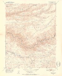
1950 Map of Devil Peak
USGS Topo · Published 1952About this map
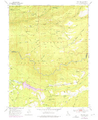
Eldorado National Forest terrain dominates this mid-century survey, defined by the deep winding path of the Rubicon River as it carves through the Sierra Nevada foothills. The landscape is a map of waning industrial activity, marked by several dormant mining operations such as the Clydesdale Mine and the Pigeon Roost Mine. These sites, along with a solitary Ruin near Zuver, point to a period of earlier resource extraction that has since transitioned toward timber and ranching. Small settlements and specialized dwellings like Blacksmith Flat, Vaughn Cabin, and Pilot Creek House are scattered across the high ridges, connected by a network of trails rather than developed roads.
Find a feature on this map
55 named features on this map. Tap any name to fly to it.
Don’t see what you’re looking for? This feature index may not catch every label — zoom into the map to look around manually.
Map Details
Editions of this 1950 Devil Peak Map
7 editions found
Other maps of this area

1889 · Pyramid Peak
USGS Topo · 1:125,000

1891 · Colfax
USGS Topo · 1:125,000

1891 · Truckee
USGS Topo · 1:125,000

1891 · Placerville
USGS Topo · 1:125,000

1891 · Pyramid Peak
USGS Topo · 1:125,000

1892 · Placerville
USGS Topo · 1:125,000

1892 · Colfax
USGS Topo · 1:125,000

1893 · Placerville
USGS Topo · 1:125,000

1893 · Truckee
USGS Topo · 1:125,000

1894 · Colfax
USGS Topo · 1:125,000