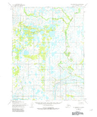
1954 Map of Dillingham B-1
USGS Topo · Published 1981About this map
The Kvichak River dominates the southern landscape of this mid-century survey, a vital waterway winding through a complex system of ponds and marshes in the Lake and Peninsula region. Photogrammetric methods from 1955 aerial photography reveal an intricate hydrology, where the main channel of the Kvichak is fed by several notable tributaries including Kaskanak Creek, which meanders significantly through the central and northeastern sections. Further south and west, the smaller Courtney Creek and Ole Creek cut through the terrain, illustrating the water-saturated nature of this environment during the 1950s. The absence of roads or trails throughout the entire quadrangle highlights the reliance on river navigation and the seasonal fluctuations of the wetlands, documented here with 25-foot contour intervals to track subtle shifts in elevation.
Find a feature on this map
4 named features on this map. Tap any name to fly to it.
Don’t see what you’re looking for? This feature index may not catch every label — zoom into the map to look around manually.
Map Details
Editions of this 1954 Dillingham B-1 Map
2 editions found
Other maps of this area

1951 · Dillingham
USGS Topo · 1:250,000

1951 · Iliamna A-8
USGS Topo · 1:63,360

1951 · Dillingham A-1
USGS Topo · 1:63,360

1952 · Iliamna
USGS Topo · 1:250,000

1952 · Dillingham A-2
USGS Topo · 1:63,360
1952 · Iliamna A-8
USGS Topo · 1:63,360

1954 · Iliamna C-8
USGS Topo · 1:63,360

1954 · Dillingham
USGS Topo · 1:250,000
1954 · Iliamna B-8
USGS Topo · 1:63,360

1954 · Dillingham C-1
USGS Topo · 1:63,360