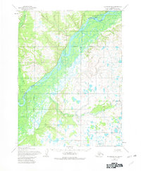
1954 Map of Dillingham B-4
USGS Topo · Published 1981About this map
The Nushagak River dominates this mid-century Alaskan landscape, serving as the primary corridor for movement and settlement in the Dillingham region. Established along its banks are the communities of New Stuyahok and Ekwok, both of which are shown with dedicated Landing Strip facilities, highlighting the critical role of bush aviation in the interior. The presence of Tunravik (Site) near Tunravik Creek suggests a history of seasonal or former habitation along the northern reaches of the river. The terrain is characterized by a complex network of waterways, including Klutuk Creek, Lower Klutuk Creek, and Lookout Creek, which meander through the marshy lowlands. This survey reflects the infrastructure of the 1950s, documenting a Gaging Sta and clear corporate boundaries that define the spatial organization of these riverside settlements during a period of documented growth.
Find a feature on this map
11 named features on this map. Tap any name to fly to it.
Don’t see what you’re looking for? This feature index may not catch every label — zoom into the map to look around manually.
Map Details
Editions of this 1954 Dillingham B-4 Map
2 editions found
Other maps of this area

1951 · Dillingham
USGS Topo · 1:250,000

1952 · Dillingham A-5
USGS Topo · 1:63,360

1952 · Dillingham A-4
USGS Topo · 1:63,360

1952 · Dillingham A-3
USGS Topo · 1:63,360

1954 · Dillingham
USGS Topo · 1:250,000

1954 · Dillingham B-4
USGS Topo · 1:63,360

1954 · Dillingham C-3
USGS Topo · 1:63,360

1954 · Dillingham B-3
USGS Topo · 1:63,360
1954 · Dillingham B-5
USGS Topo · 1:63,360

1954 · Dillingham C-4
USGS Topo · 1:63,360