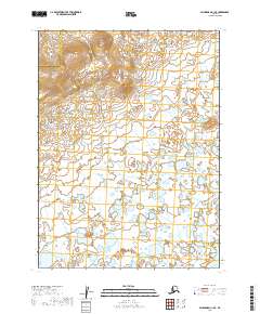
2019 Map of Dillingham C-1 SE
USGS Topo · Published 2019About this map
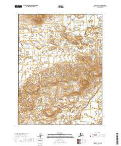
The Lake and Peninsula Borough and Dillingham Census Area border runs through this remote landscape, where the terrain transitions from high ridges in the northwest to an expansive wetland complex in the south and east. The topography is defined by significant elevation changes, with contours rising above 1,300 feet in the northern reaches of the quadrangle. As the land slopes downward, it gives way to a dense network of ponds and saturated ground typical of the Bristol Bay region. Flowing across the southeast corner, Kaskanak Cr serves as a primary drainage for these lowlands. This survey illustrates the intricate relationship between the elevated divides and the sprawling water systems that characterize the interior of southwestern Alaska.
Find a feature on this map
9 named features on this map. Tap any name to fly to it.
Don’t see what you’re looking for? This feature index may not catch every label — zoom into the map to look around manually.
Map Details
Editions of this 2019 Dillingham C-1 SE Map
This is the sole edition of this map. No revisions or reprints were ever made.
Other maps of this area

1951 · Dillingham
USGS Topo · 1:250,000

1952 · Iliamna
USGS Topo · 1:250,000

1954 · Iliamna C-8
USGS Topo · 1:63,360

1954 · Dillingham
USGS Topo · 1:250,000
1954 · Iliamna B-8
USGS Topo · 1:63,360

1954 · Dillingham C-1
USGS Topo · 1:63,360
1954 · Dillingham B-1
USGS Topo · 1:63,360

1957 · Iliamna
USGS Topo · 1:250,000
2019 · Iliamna C-8 SW
USGS Topo · 1:25,000
2019 · Iliamna C-8 NW
USGS Topo · 1:25,000