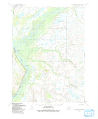
1954 Map of Dillingham C-3
USGS Topo · Published 1991About this map
The confluence of the Nushagak River and the Mulchatna River dominates this mid-century interior landscape, revealing a remote riverine system in southwestern Alaska. The settlement at Nunachuak sits along the banks where the waters meet, accompanied by scattered Cabins further downstream that suggest a seasonal or subsistence-based presence in the 1950s. The terrain is defined by complex drainage patterns, with the winding Nunachuak Creek and Tumaguli Creek carving through the lowlands. The survey, based on aerial photography from 1953 and 1955, shows a wilderness primarily accessible by water, prior to significant modern infrastructure development in the region.
Find a feature on this map
6 named features on this map. Tap any name to fly to it.
Don’t see what you’re looking for? This feature index may not catch every label — zoom into the map to look around manually.
Map Details
Editions of this 1954 Dillingham C-3 Map
2 editions found
Other maps of this area

1951 · Dillingham
USGS Topo · 1:250,000

1954 · Dillingham
USGS Topo · 1:250,000

1954 · Dillingham B-4
USGS Topo · 1:63,360

1954 · Dillingham C-3
USGS Topo · 1:63,360

1954 · Dillingham D-2
USGS Topo · 1:63,360
1954 · Dillingham B-2
USGS Topo · 1:63,360

1954 · Dillingham B-3
USGS Topo · 1:63,360

1954 · Dillingham D-3
USGS Topo · 1:63,360

1954 · Dillingham C-2
USGS Topo · 1:63,360

1954 · Dillingham D-4
USGS Topo · 1:63,360