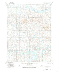
1954 Map of Dillingham D-2
USGS Topo · Published 1985About this map
Stuyahok River winds through the northern portion of this Alaskan interior landscape, a region defined by complex drainage patterns and low-lying wetlands. The Stuyahok Hills rise as the primary topographic prominence in the northeast, providing a rare break in the expanse of small lakes and unnamed ponds that cover much of the terrain. Mapped primarily through aerial photography from the mid-1950s, the area is characterized by an absence of roads or established settlements, reflecting the remote nature of the Dillingham district during the mid-twentieth century. The intricate web of water bodies suggests a dynamic hydrological environment where land and water constantly intermingle, a typical feature of the region's subarctic geography.
Find a feature on this map
2 named features on this map. Tap any name to fly to it.
Don’t see what you’re looking for? This feature index may not catch every label — zoom into the map to look around manually.
Map Details
Editions of this 1954 Dillingham D-2 Map
3 editions found
Other maps of this area

1950 · Taylor Mountains
USGS Topo · 1:250,000

1951 · Taylor Mountains
USGS Topo · 1:250,000

1951 · Dillingham
USGS Topo · 1:250,000

1954 · Taylor Mountains
USGS Topo · 1:250,000

1954 · Dillingham
USGS Topo · 1:250,000

1954 · Dillingham C-3
USGS Topo · 1:63,360

1954 · Dillingham D-2
USGS Topo · 1:63,360

1954 · Dillingham C-1
USGS Topo · 1:63,360

1954 · Dillingham D-3
USGS Topo · 1:63,360

1954 · Dillingham C-2
USGS Topo · 1:63,360