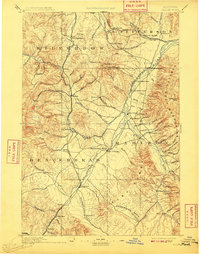
1893 Map of Dillon
USGS Topo · Published 1909About this map
Dillon serves as the focal point of this southwestern Montana landscape, situated along the Oregon Short Line railroad. The map documents a critical period of territorial development where mining activity and ranching intersected at the base of the Ruby Range and the Tobacco Root Mountains. In the west, high-altitude mining settlements like Hecla and Glendale appear near the Continental Divide, while the eastern portion is dominated by the Passamari and Jefferson River drainage systems. Topographers Frank Tweedy and A.H. Thompson captured the region's complex terrain, from the Sweetwater Basin to the prominent landmark of Beaverhead Rock. The presence of numerous gulches, such as Harris Gulch and Bivin Gulch, underscores the era's focus on mineral extraction and the rapid growth of towns like Rochester and Sheridan.
Find a feature on this map
93 named features on this map. Tap any name to fly to it.
Don’t see what you’re looking for? This feature index may not catch every label — zoom into the map to look around manually.
Map Details
Editions of this 1893 Dillon Map
5 editions found
Other maps of this area

1886 · Fort Logan
USGS Topo · 1:250,000

1888 · Three Forks
USGS Topo · 1:250,000

1889 · Helena
USGS Topo · 1:250,000

1893 · Helena
USGS Topo · 1:250,000

1893 · Dillon
USGS Topo · 1:250,000

1894 · Three Forks
USGS Topo · 1:250,000

1895 · Three Forks
USGS Topo · 1:250,000

1899 · Boulder
USGS Topo · 1:125,000

1899 · Helena
USGS Topo · 1:250,000

1903 · Helena
USGS Topo · 1:250,000