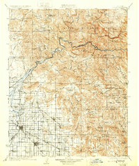
1924 Map of Dinuba
USGS Topo · Published 1930About this map
The Kings River carves a path between the Sierra National Forest and Sequoia National Forest, defining a landscape where the Sierra Nevada foothills meet the fertile San Joaquin Valley. This 1920s-era geography reveals the transition from high timber and mining country, marked by the Sunnyside Mine and the engineering feat of the Sanger Flume, to an burgeoning agricultural engine. The valley floor is crisscrossed by irrigation infrastructure like the Alta Canal and Smith Mountain Canal, supporting a network of small settlements and industrial landmarks including the Wahtoke Winery. Long-standing family operations such as Jorgensen Ranch and Auckland Ranch sit alongside dozens of rural schoolhouses, from Mechanicsville School to the Sycamore Creek Indian School, documenting the dense social fabric of the early twentieth-century Central Valley.
Find a feature on this map
162 named features on this map. Tap any name to fly to it.
Don’t see what you’re looking for? This feature index may not catch every label — zoom into the map to look around manually.
Map Details
Editions of this 1924 Dinuba Map
5 editions found

Other maps of this area

1903 · Tehipite
USGS Topo · 1:125,000

1904 · Kaiser
USGS Topo · 1:125,000

1904 · Kaweah
USGS Topo · 1:125,000

1905 · Tehipite
USGS Topo · 1:125,000

1909 · Kaweah
USGS Topo · 1:125,000

1912 · Mariposa
USGS Topo · 1:125,000

1912 · Mt. Goddard
USGS Topo · 1:125,000

1920 · Orangedale School
USGS Topo · 1:24,000

1921 · Squaw Valley
USGS Topo · 1:31,680

1921 · Stokes Mountain
USGS Topo · 1:24,000