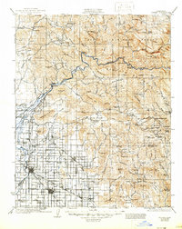
1924 Map of Dinuba
USGS Topo · Published 1947About this map
The Kings River serves as the central artery for this 1920s landscape, illustrating the transition from the high ridges of the Sierra National Forest to the irrigated valley floor. The presence of the Sanger Flume and the Enterprise Canal highlights the sophisticated water management that transformed the region into a citrus and grape powerhouse. This agricultural identity is anchored by the Wahtoke Winery and numerous small settlements like Navelencia and Orange Cove.
Find a feature on this map
149 named features on this map. Tap any name to fly to it.
Don’t see what you’re looking for? This feature index may not catch every label — zoom into the map to look around manually.
Map Details
Editions of this 1924 Dinuba Map
5 editions found

Other maps of this area

1903 · Tehipite
USGS Topo · 1:125,000

1904 · Kaiser
USGS Topo · 1:125,000

1904 · Kaweah
USGS Topo · 1:125,000

1905 · Tehipite
USGS Topo · 1:125,000

1909 · Kaweah
USGS Topo · 1:125,000

1912 · Mariposa
USGS Topo · 1:125,000

1912 · Mt. Goddard
USGS Topo · 1:125,000

1920 · Orangedale School
USGS Topo · 1:24,000

1921 · Squaw Valley
USGS Topo · 1:31,680

1921 · Stokes Mountain
USGS Topo · 1:24,000