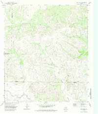
1972 Map of Dog Creek
USGS Topo · Published 1985About this map
Funk Oil Field anchors the southern portion of this West Texas landscape, showing the industrial footprint of petroleum extraction in the early 1970s. Located at the intersection of Tom Green, Irion, and Sterling counties, the terrain is defined by a network of seasonal watercourses and upland rises. Significant drainage features including Dog Creek, Live Oak Creek, and Dry Rocky Creek carve through the plateau, while a prominent Pipeline cuts across the western hills. The map captures the infrastructure of the era, from scattered Oil Wells and Drill Holes to the local elevation of McCrary. This survey serves as a record of the region before further modern developments altered the ranching and energy-producing landscape of the Concho Valley hinterlands.
Find a feature on this map
16 named features on this map. Tap any name to fly to it.
Don’t see what you’re looking for? This feature index may not catch every label — zoom into the map to look around manually.
Map Details
Editions of this 1972 Dog Creek Map
3 editions found
Other maps of this area

1895 · Sherwood
USGS Topo · 1:125,000

1928 · Tankersly
USGS Topo · 1:62,500

1954 · San Angelo
USGS Topo · 1:250,000

1957 · Carlsbad
USGS Topo · 1:62,500

1957 · Knickerbocker
USGS Topo · 1:62,500

1958 · San Angelo
USGS Topo · 1:250,000

1965 · San Angelo
USGS Topo · 1:250,000

1972 · Arden
USGS Topo · 1:24,000

1972 · Dog Creek NE
USGS Topo · 1:24,000

1972 · Wallace Draw
USGS Topo · 1:24,000