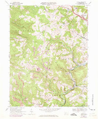
1967 Map of Donegal
USGS Topo · Published 1973About this map
Chestnut Ridge defines the western landscape of this 1967 survey, while the eastern edge follows the corridor of the Pennsylvania Turnpike near Donegal. The economy of the era is clearly visible through the numerous strip mines and mine dumps that dot the hillsides, particularly near White and Melcroft. Transport and industrial patterns center on the Baltimore and Ohio railroad line which snakes along Indian Creek, connecting small settlements like Davistown, Sagamore, and Indian Head. Local life is anchored by landmarks such as Mt Zion Ch and Lake Donegal, while the terrain rises to notable peaks like Jockey Knob and Sun Hill. Small enclaves and family-named landmarks such as Coffman and Millertown are documented before significant late-20th-century development altered the character of these rural communities near the Westmoreland and Fayette county line.
Find a feature on this map
52 named features on this map. Tap any name to fly to it.
Don’t see what you’re looking for? This feature index may not catch every label — zoom into the map to look around manually.
Map Details
Editions of this 1967 Donegal Map
4 editions found
Other maps of this area

1900 · Uniontown
USGS Topo · 1:62,500

1902 · Connellsville
USGS Topo · 1:62,500

1922 · Confluence
USGS Topo · 1:62,500

1922 · Donegal
USGS Topo · 1:62,500

1931 · Connellsville
USGS Topo · 1:62,500

1931 · Uniontown
USGS Topo · 1:62,500

1931 · Confluence
USGS Topo · 1:62,500

1933 · Confluence
USGS Topo · 1:62,500

1935 · Donegal
USGS Topo · 1:62,500

1936 · Connellsville
USGS Topo · 1:62,500
Featured Places
- Donegal, PA
- Bullskin Township, PA
- Springfield Township, PA
- Saltlick Township, PA
- Mount Pleasant Township, PA