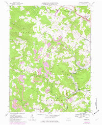
1967 Map of Donegal
USGS Topo · Published 1979About this map
Chestnut Ridge defines the western terrain of this 1967 survey, where the rugged slopes of the Laurel Highlands meet the industrial heart of southwestern Pennsylvania. The landscape is a complex patchwork of extractive industry and rural life, marked by numerous Strip Mine operations and Mine Dump sites that follow the coal seams through the hills. Along the winding course of Indian Creek, settlements like Melcroft and Indian Head developed around the Baltimore and Ohio railroad corridor, which served the region's mines. To the north, the Pennsylvania Turnpike cuts across the corner near Donegal, signaling a shift toward modern transportation. This map offers a detailed view of family-named landmarks and local institutions, from Mt Zion Ch to the quiet waters of Lake Donegal, capturing the area as it balanced the demands of timber and coal with its emerging character as a recreational gateway at Bear Rocks.
Find a feature on this map
48 named features on this map. Tap any name to fly to it.
Don’t see what you’re looking for? This feature index may not catch every label — zoom into the map to look around manually.
Map Details
Editions of this 1967 Donegal Map
4 editions found
Other maps of this area

1900 · Uniontown
USGS Topo · 1:62,500

1902 · Connellsville
USGS Topo · 1:62,500

1922 · Confluence
USGS Topo · 1:62,500

1922 · Donegal
USGS Topo · 1:62,500

1931 · Connellsville
USGS Topo · 1:62,500

1931 · Uniontown
USGS Topo · 1:62,500

1931 · Confluence
USGS Topo · 1:62,500

1933 · Confluence
USGS Topo · 1:62,500

1935 · Donegal
USGS Topo · 1:62,500

1936 · Connellsville
USGS Topo · 1:62,500
Featured Places
- Donegal, PA
- Bullskin Township, PA
- Springfield Township, PA
- Saltlick Township, PA
- Mount Pleasant Township, PA