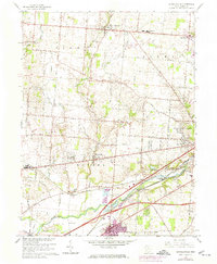
1965 Map of Donnelsville
USGS Topo · Published 1974About this map
The Mad River valley in Clark County defines a landscape shaped by transportation and community institutions during the mid-1960s. The historic National Road cuts across the center of the sheet, anchoring the village of Donnelsville, while the Penn Central and Erie-Lackawanna railroads follow the river's path to the south. This corridor supported a mix of industry and recreation, evidenced by the Sand and Gravel Pit and the preserved lands of George Rogers Clark State Park.
Find a feature on this map
55 named features on this map. Tap any name to fly to it.
Don’t see what you’re looking for? This feature index may not catch every label — zoom into the map to look around manually.
Map Details
Editions of this 1965 Donnelsville Map
3 editions found
Other maps of this area

1904 · Springfield
USGS Topo · 1:62,500

1904 · Dayton
USGS Topo · 1:62,500

1906 · Dayton
USGS Topo · 1:62,500

1906 · Springfield
USGS Topo · 1:62,500

1914 · Troy
USGS Topo · 1:62,500

1914 · St. Paris
USGS Topo · 1:62,500

1916 · St. Paris
USGS Topo · 1:62,500

1944 · St. Paris
USGS Topo · 1:62,500

1944 · Troy
USGS Topo · 1:62,500

1947 · Columbus
USGS Topo · 1:250,000