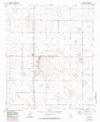
1972 Map of Dora
USGS Topo · Published 1985About this map
Dora serves as the central hub of this High Plains landscape, its grid defined by a clear Corporate Boundary during the early 1970s. The settlement's infrastructure is tightly clustered, reflecting a compact community surrounded by agricultural lands and industrial extraction sites. To the north, Mt Zion Cem marks a significant local landmark for genealogical research, while the surrounding terrain is punctuated by numerous wells, indicating the vital importance of groundwater to the region's survival and economy. Further south, the map identifies Burkett, a smaller named locality that highlights the dispersed nature of rural settlement in Roosevelt County. The presence of several Gravel Pits suggests active local industry, showing where materials were harvested to build the roads and foundations of the growing town.
Find a feature on this map
8 named features on this map. Tap any name to fly to it.
Don’t see what you’re looking for? This feature index may not catch every label — zoom into the map to look around manually.
Map Details
Editions of this 1972 Dora Map
2 editions found

Other maps of this area

1954 · Clovis
USGS Topo · 1:250,000

1954 · Brownfield
USGS Topo · 1:250,000

1957 · Arch
USGS Topo · 1:62,500

1957 · Portales
USGS Topo · 1:62,500

1958 · Brownfield
USGS Topo · 1:250,000

1958 · Clovis
USGS Topo · 1:250,000

1962 · Brownfield
USGS Topo · 1:250,000

1972 · Dora NW
USGS Topo · 1:24,000

1972 · Garrison
USGS Topo · 1:24,000

1972 · Dora SW
USGS Topo · 1:24,000