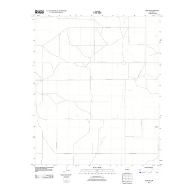
2010 Map of Dora SW
USGS Topo · Published 2010About this map
New Hope Cemetery stands as a solitary landmark in this agricultural landscape within Roosevelt County, appearing at the corner of S Roosevelt Road 32 and S Roosevelt Road T. The map reveals a strictly regulated Jeffersonian grid, where the movement of people and commerce is defined by a geometric network of county roads. These thoroughfares, including S Roosevelt Road 34 and S Roosevelt Road 30, carve the Llano Estacado into precise sections for ranching and dry-land farming. The spatial organization shown here represents the high-plains settlement pattern of eastern New Mexico in the early 21st century, where large-scale land management dominates the terrain and local heritage is preserved in isolated pockets like the cemetery at the eastern edge.
Find a feature on this map
11 named features on this map. Tap any name to fly to it.
Don’t see what you’re looking for? This feature index may not catch every label — zoom into the map to look around manually.
Map Details
Editions of this 2010 Dora SW Map
This is the sole edition of this map. No revisions or reprints were ever made.
Other maps of this area

1954 · Brownfield
USGS Topo · 1:250,000

1958 · Brownfield
USGS Topo · 1:250,000

1962 · Brownfield
USGS Topo · 1:250,000
1972 · Dora NW
USGS Topo · 1:24,000
1972 · Milnesand
USGS Topo · 1:24,000
1972 · Dora SW
USGS Topo · 1:24,000
1972 · Pep
USGS Topo · 1:24,000
1972 · Milnesand NW
USGS Topo · 1:24,000
1972 · Dora
USGS Topo · 1:24,000
1979 · Badger Lake
USGS Topo · 1:24,000