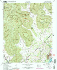
1967 Map of Doran Cove
USGS Topo · Published 1991About this map
Russell Cave National Monument anchors this 1967 survey of the Alabama-Tennessee border, preserving a site of ancient human habitation within the dramatic karst landscape of Doran Cove. The map illustrates the industrial and agricultural interface of Jackson County, where the Widows Creek Steam Plant stands near the banks of Guntersville Lake and the Tennessee River. This era shows a landscape transitioning through modern infrastructure while maintaining deep local roots, visible in the numerous family cemeteries such as Hackworth Cem and Brown-Cox Cem.
Find a feature on this map
105 named features on this map. Tap any name to fly to it.
Don’t see what you’re looking for? This feature index may not catch every label — zoom into the map to look around manually.
Map Details
Editions of this 1967 Doran Cove Map
4 editions found
Other maps of this area

1886 · Stevenson
USGS Topo · 1:125,000

1892 · Stevenson
USGS Topo · 1:125,000

1895 · Stevenson
USGS Topo · 1:125,000

1895 · Sewanee
USGS Topo · 1:125,000

1936 · Orme
USGS Topo · 1:24,000

1936 · Bridgeport
USGS Topo · 1:24,000

1936 · Wannville
USGS Topo · 1:24,000

1936 · Flat Rock
USGS Topo · 1:24,000

1936 · Sinking Cove
USGS Topo · 1:24,000

1936 · Stevenson
USGS Topo · 1:24,000