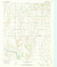
1964 Map of Dozier
USGS Topo · Published 1967About this map
The Salt Fork Red River cuts through the southern reaches of this Collingsworth County landscape, defining the topography of a region balanced between ranching and resource extraction in the mid-1960s. Central to the local economy is the extensive Gas Field that spreads across the northern plains, while the Fort Worth and Denver railroad provides the primary industrial artery through the eastern half of the quadrangle. The small settlements of Dozier and Samnorwood serve as the primary hubs of activity, surrounded by a network of drainage systems like Dozier Creek and Lake Creek. Local heritage is anchored by sites such as Dozier Cem and Plymouth Cem, which offer significant value for genealogists tracing early families in this corner of the Texas Panhandle. Several Gravel Pits are also scattered near the river, signaling the ongoing extraction and infrastructure development of the era.
Find a feature on this map
12 named features on this map. Tap any name to fly to it.
Don’t see what you’re looking for? This feature index may not catch every label — zoom into the map to look around manually.
Map Details
Editions of this 1964 Dozier Map
This is the sole edition of this map. No revisions or reprints were ever made.
Other maps of this area

1954 · Amarillo
USGS Topo · 1:250,000

1954 · Plainview
USGS Topo · 1:250,000

1958 · Amarillo
USGS Topo · 1:250,000

1958 · Plainview
USGS Topo · 1:250,000

1959 · Wellington NW
USGS Topo · 1:24,000

1963 · Ramsdell
USGS Topo · 1:24,000

1963 · Shamrock East
USGS Topo · 1:24,000

1963 · Shamrock West
USGS Topo · 1:24,000

1964 · Rolla NE
USGS Topo · 1:24,000

1964 · Quail
USGS Topo · 1:24,000