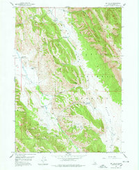
1949 Map of Dry Valley
USGS Topo · Published 1978About this map
The Caribou National Forest in Caribou County, Idaho, is depicted here during the late 1940s, revealing a landscape defined by ranching and resource management. Settlement is characterized by widely dispersed family operations such as the Petterson Ranch, Knudsen Ranch, and Young Ranch, mostly situated along the watercourses of Dry Valley Creek and Slug Creek. The presence of the Dry Valley Guard Sta indicates the active role of the forest service in overseeing this high-elevation terrain.
Find a feature on this map
33 named features on this map. Tap any name to fly to it.
Don’t see what you’re looking for? This feature index may not catch every label — zoom into the map to look around manually.
Map Details
Editions of this 1949 Dry Valley Map
3 editions found
Other maps of this area

1911 · Slug Creek
USGS Topo · 1:62,500

1915 · Freedom
USGS Topo · 1:62,500

1915 · Crow Creek
USGS Topo · 1:62,500

1915 · Lanes Creek
USGS Topo · 1:62,500

1949 · Johnson Creek
USGS Topo · 1:24,000

1949 · Stewart Flat
USGS Topo · 1:24,000

1949 · Dry Valley
USGS Topo · 1:24,000

1949 · Snowdrift Mountain
USGS Topo · 1:24,000

1949 · Lower Valley
USGS Topo · 1:24,000

1951 · Lower Valley
USGS Topo · 1:24,000