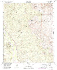
1949 Map of Dudleyville
USGS Topo · Published 1986About this map
San Pedro River waters define the western edge of this landscape, supported by the engineering of the San Manuel Ditch to channel resources through the arid terrain. The map captures a transition from the riparian valley floor up into the complex elevations of Saddle Mtn and Malpais Hill. Evidence of local industry and ranching is scattered throughout the survey, from the Gypsum Mines and their associated Tailings in the south to established family operations like Eskimazene Ranch and Whittaker Ranch. Remote outposts such as Kelleys Camp and natural landmarks like Crystal Cave illustrate how the geography was utilized and named by those working the land. Numerous seasonal drainages, including Roach Wash and Eskimazene Wash, emphasize the importance of reliable water sources like Piper Springs and Carrico Spr for sustainment in this Pinal County region.
Find a feature on this map
28 named features on this map. Tap any name to fly to it.
Don’t see what you’re looking for? This feature index may not catch every label — zoom into the map to look around manually.
Map Details
Editions of this 1949 Dudleyville Map
4 editions found
Other maps of this area

1910 · Ray
USGS Topo · 1:62,500

1911 · Winkelman
USGS Topo · 1:125,000

1913 · Winkelman
USGS Topo · 1:125,000

1915 · Christmas
USGS Topo · 1:62,500

1917 · Christmas
USGS Topo · 1:62,500

1949 · Holy Joe Peak
USGS Topo · 1:62,500

1949 · Winkelman
USGS Topo · 1:24,000

1949 · Winkelman
USGS Topo · 1:62,500

1949 · Saddle Mtn.
USGS Topo · 1:24,000

1949 · Brandenburg Mtn
USGS Topo · 1:24,000