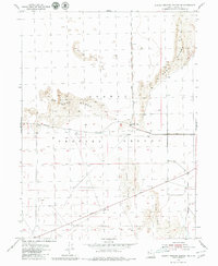
1954 Map of Dugway Proving Ground NE
USGS Topo · Published 1980About this map
The Baker Area sits at the intersection of desert survival and mid-century military operations within the Dugway Proving Ground. This 1954 survey by the Geological Survey documents a landscape defined by movement through shifting Sand Dunes, where the isolation of the Tooele County desert is pierced only by a sparse network of military routes. Tactical mobility is reflected in the placement of Goodyear Road and Stark Road, which cut straight lines across the basin floor. The reliance on remote outposts is evidenced by a lone Well and numerous survey markers, such as BM 4301 and BM 4307, which served as the precise benchmarks for mapping this high-altitude desert terrain before the advent of modern satellite systems.
Find a feature on this map
17 named features on this map. Tap any name to fly to it.
Don’t see what you’re looking for? This feature index may not catch every label — zoom into the map to look around manually.
Map Details
Editions of this 1954 Dugway Proving Ground NE Map
4 editions found
Other maps of this area

1885 · Tooele Valley
USGS Topo · 1:250,000

1953 · Tooele
USGS Topo · 1:250,000

1954 · Wig Mtn SW
USGS Topo · 1:24,000

1954 · Dugway Proving Ground SE
USGS Topo · 1:24,000

1954 · Dugway Proving Ground NE
USGS Topo · 1:24,000

1954 · Dugway Proving Ground SW
USGS Topo · 1:24,000

1954 · Camels Back Ridge NW
USGS Topo · 1:24,000

1954 · Dugway Proving Ground NW
USGS Topo · 1:24,000

1955 · Camels Back Ridge SW
USGS Topo · 1:24,000

1955 · Wig Mtn
USGS Topo · 1:24,000