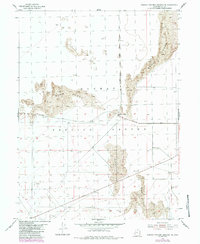
1954 Map of Dugway Proving Ground NE
USGS Topo · Published 1984About this map
Dugway Proving Ground defines this military landscape in western Utah, surveyed originally in the 1950s with updates from the early 1980s. The terrain is characterized by massive formations of Sand Dunes that shift across the desert floor, creating a complex environment for the tactical operations and testing conducted here. The Baker Area serves as a localized hub of development, while remote transit is facilitated by desert tracks like Goodyear Road and Stark Road. Numerous bench marks, including BM 4307 and BM 4319, provide a network of precise elevation points across the arid expanse. This survey captures a moment when military infrastructure and shifting desert geology intersected during the mid-century era of weapons research and development.
Find a feature on this map
15 named features on this map. Tap any name to fly to it.
Don’t see what you’re looking for? This feature index may not catch every label — zoom into the map to look around manually.
Map Details
Editions of this 1954 Dugway Proving Ground NE Map
4 editions found
Other maps of this area

1885 · Tooele Valley
USGS Topo · 1:250,000

1953 · Tooele
USGS Topo · 1:250,000

1954 · Wig Mtn SW
USGS Topo · 1:24,000

1954 · Dugway Proving Ground SE
USGS Topo · 1:24,000

1954 · Dugway Proving Ground NE
USGS Topo · 1:24,000

1954 · Dugway Proving Ground SW
USGS Topo · 1:24,000

1954 · Camels Back Ridge NW
USGS Topo · 1:24,000

1954 · Dugway Proving Ground NW
USGS Topo · 1:24,000

1955 · Camels Back Ridge SW
USGS Topo · 1:24,000

1955 · Wig Mtn
USGS Topo · 1:24,000