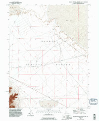
1993 Map of Dugway Proving Ground NW
USGS Topo · Published 1996About this map
The Dugway Proving Ground military installation dominates this arid landscape in Tooele County, as documented in this 1993 revision based on decades of topographical data. The terrain is characterized by expansive, level features including the vast Mud Flat and the seasonally empty basin of Dry Lake. This specialized military environment is crisscrossed by a sparse network of strategic access routes, notably Falconer Road, Goodyear Road, and Stark Road. The map provides a rare look at the infrastructure of the proving ground during the late twentieth century, including scattered Pits and surveying benchmarks that hint at the technical and testing activities conducted across the Great Salt Lake Desert. The precise five-foot contour intervals reveal the subtle variations in this otherwise remarkably flat desert floor.
Find a feature on this map
9 named features on this map. Tap any name to fly to it.
Don’t see what you’re looking for? This feature index may not catch every label — zoom into the map to look around manually.
Map Details
Editions of this 1993 Dugway Proving Ground NW Map
This is the sole edition of this map. No revisions or reprints were ever made.
Other maps of this area

1953 · Tooele
USGS Topo · 1:250,000

1954 · Wig Mtn SW
USGS Topo · 1:24,000

1954 · Dugway Proving Ground SE
USGS Topo · 1:24,000

1954 · Dugway Proving Ground NE
USGS Topo · 1:24,000

1954 · Granite Peak
USGS Topo · 1:24,000

1954 · Dugway Proving Ground SW
USGS Topo · 1:24,000

1954 · Wildcat Mtn SE
USGS Topo · 1:24,000

1954 · Dugway Proving Ground NW
USGS Topo · 1:24,000

1954 · Granite Peak SE
USGS Topo · 1:24,000

1955 · Wig Mtn
USGS Topo · 1:24,000