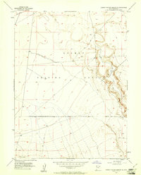
1954 Map of Dugway Proving Ground SE
USGS Topo · Published 1961About this map
Dugway Proving Ground occupies this Tooele County terrain, mapped in the early 1950s primarily via aerial photography and plane-table methods. The topography is defined by the prehistoric remnants of the Old River Bed, a significant geological feature that carved a wide channel through the desert floor. This arid landscape is sparsely marked by human activity, with access limited to a network of Jeep Trails that cross the alluvial fans and salt flats. The survey captures the area at a time of increased military testing and isolation, where the natural drainage patterns and ancient lakebed levels remain the dominant features of the quadrangle.
Find a feature on this map
3 named features on this map. Tap any name to fly to it.
Don’t see what you’re looking for? This feature index may not catch every label — zoom into the map to look around manually.
Map Details
Editions of this 1954 Dugway Proving Ground SE Map
4 editions found
Other maps of this area

1885 · Sevier Desert
USGS Topo · 1:250,000

1885 · Tooele Valley
USGS Topo · 1:250,000

1908 · Fish Springs
USGS Topo · 1:250,000

1910 · Fish Springs
USGS Topo · 1:250,000

1953 · Dugway Range NE
USGS Topo · 1:24,000

1953 · Dugway Range
USGS Topo · 1:62,500

1953 · Dugway Range NW
USGS Topo · 1:24,000

1953 · Tooele
USGS Topo · 1:250,000

1953 · Delta
USGS Topo · 1:250,000

1954 · Dugway Proving Ground SE
USGS Topo · 1:24,000