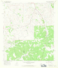
1967 Map of Dunbar Draw SW
USGS Topo · Published 1971About this map
Mack Cauthorn Ranch and other family holdings define this high plains landscape at the intersection of Sutton, Val Verde, and Edwards Counties during the late 1960s. The region is characterized by an intricate network of ephemeral drainage systems, most notably Cauthorn Draw and the various branches of Buckley Draw. This survey illustrates a ranching economy reliant on isolated water sources and localized industry, evidenced by features such as Chester Well, Buckley Tank, and scattered Gravel Pits. The topography reveals the transition from relatively level tablelands to the dissected draws of the Edwards Plateau. Notable landmarks like the Roadside Park along the highway and specific sites like a Drill Hole provide unique markers for those tracing property boundaries or industrial activity in this specific corner of West Texas.
Find a feature on this map
16 named features on this map. Tap any name to fly to it.
Don’t see what you’re looking for? This feature index may not catch every label — zoom into the map to look around manually.
Map Details
Editions of this 1967 Dunbar Draw SW Map
Other maps of this area

1954 · Sonora
USGS Topo · 1:250,000

1958 · Sonora
USGS Topo · 1:250,000

1967 · Dunbar Draw SW
USGS Topo · 1:24,000

1967 · Flat Rock Draw SE
USGS Topo · 1:24,000

1967 · Dunbar Draw NW
USGS Topo · 1:24,000

1967 · Dunbar Draw NE
USGS Topo · 1:24,000

1967 · Hudspeth Draw
USGS Topo · 1:24,000

1967 · Dunbar Draw SE
USGS Topo · 1:24,000
1971 · Turney Draw NE
USGS Topo · 1:24,000

1973 · Turney Draw NW
USGS Topo · 1:24,000