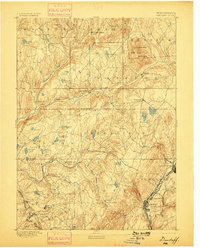
1892 Map of Dundaff
USGS Topo · Published 1898About this map
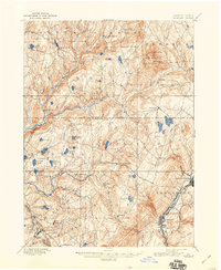
Carbondale and the northern coal fields of the Lackawanna Valley anchor the southeastern corner of this late 19th-century survey. The landscape transitions from the industrial activity of the Delaware & Hudson Canal Co. RR. and Jermyn into a high, glaciated plateau characterized by numerous bodies of water like Newton Lake and Crystal Lake. Prominent elevations such as Elk Hill, including North Knob and South Knob, dominate the northeastern terrain near Dundaff. The drainage patterns of the Tunkhannock Creek and its many branches, such as the South Branch, illustrate a rural economy of small settlements like Fleetville, Lenoxville, and West Lenox connected by early wagon roads. This detailed topography, supervised by Marcus Baker, documents the region before the extensive urbanization and highway development of the 20th century.
Find a feature on this map
75 named features on this map. Tap any name to fly to it.
Don’t see what you’re looking for? This feature index may not catch every label — zoom into the map to look around manually.
Map Details
Editions of this 1892 Dundaff Map
6 editions found
Other maps of this area

1889 · Scranton
USGS Topo · 1:62,500

1891 · Scranton
USGS Topo · 1:62,500

1892 · Honesdale
USGS Topo · 1:62,500

1892 · Dundaff
USGS Topo · 1:62,500

1893 · Pittston
USGS Topo · 1:62,500

1893 · Scranton
USGS Topo · 1:62,500

1926 · Starrucca
USGS Topo · 1:62,500

1928 · Ariel
USGS Topo · 1:62,500

1930 · Starrucca
USGS Topo · 1:48,000

1932 · Ariel
USGS Topo · 1:62,500