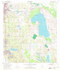
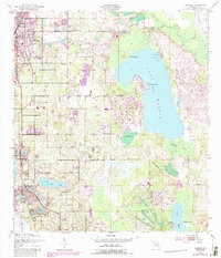
1953 Map of Dundee
USGS Topo · Published 1972About this map
The citrus ridge of Polk County is clearly defined in this mid-century survey, centered on the growing settlements of Dundee, Haines City, and Lake Hamilton. The landscape is dominated by its complex hydrology, from the large expanse of Lake Marion and its internal features like Bannon Island to the intricate chain of smaller lakes including Lake Ruth, Lake Menzie, and Lake Josephine. This era reveals a transition in Florida's transport infrastructure, with the Atlantic Coast Line and Seaboard Coast Line railroads providing the essential links for the local economy. The map also records smaller social and cultural landmarks such as the Forest Hill Cem and local activity hubs like the Boy Scout Camp and Jennings Camp, offering a detailed view of the region before the rapid suburbanization of later decades.
Find a feature on this map
29 named features on this map. Tap any name to fly to it.
Don’t see what you’re looking for? This feature index may not catch every label — zoom into the map to look around manually.
Map Details
Editions of this 1953 Dundee Map
6 editions found
Other maps of this area

1952 · Lake Wales
USGS Topo · 1:24,000

1952 · Hesperides
USGS Topo · 1:24,000

1953 · Dundee
USGS Topo · 1:24,000

1953 · Lake Hatchineha
USGS Topo · 1:24,000

1953 · Lake Tohopekaliga
USGS Topo · 1:24,000

1953 · Davenport
USGS Topo · 1:24,000

1955 · Eloise
USGS Topo · 1:24,000

1955 · Orlando
USGS Topo · 1:250,000

1956 · Fort Pierce
USGS Topo · 1:250,000

1957 · Orlando
USGS Topo · 1:250,000