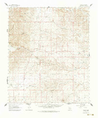
1962 Map of Dunken
USGS Topo · Published 1986About this map
Dunken anchors this 1962 landscape in Chaves County, where the high desert is defined by a network of seasonal watercourses and established cattle operations. The drainages of Rio Felix, Little Rio Felix, and the Rio Peñasco carve through the terrain, creating a series of named canyons like Thimble Canyon and Big Ox Yoke Canyon that dictate the region's layout. This era of ranching history is preserved through numerous family-named properties such as Marvin Ranch, Runyan Ranch, and the Peñasco River Ranch, each reliant on vital water sources like Alamo Well and the Dunken Windmill. The presence of the Old Featherham Place suggests an earlier layer of settlement in this arid environment. Transportation is primarily dictated by the topography, with routes like Cherry Canyon Road following the natural contours of the land between high points like Meadow Hill and the seasonal Singer Lake.
Find a feature on this map
39 named features on this map. Tap any name to fly to it.
Don’t see what you’re looking for? This feature index may not catch every label — zoom into the map to look around manually.
Map Details
Editions of this 1962 Dunken Map
3 editions found
Other maps of this area

1954 · Carlsbad
USGS Topo · 1:250,000

1955 · Roswell
USGS Topo · 1:250,000

1958 · Carlsbad
USGS Topo · 1:250,000

1958 · Roswell
USGS Topo · 1:250,000

1960 · Teel Ranch
USGS Topo · 1:62,500

1961 · Flying H
USGS Topo · 1:62,500

1961 · Indian Bluff
USGS Topo · 1:62,500

1962 · Roswell
USGS Topo · 1:250,000

1962 · Dunken
USGS Topo · 1:62,500

1963 · Clements Ranch
USGS Topo · 1:24,000