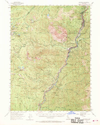
1954 Map of Dunsmuir
USGS Topo · Published 1970About this map
The Sacramento River carves a deep path through the canyon lands of the Eddy Mountains, creating a narrow corridor where the Southern Pacific RR and Pacific Highway dictate the layout of high-elevation settlements. At the heart of this corridor lies Dunsmuir, a critical mountain railroad hub, flanked by the resort-era landmarks of Shasta Retreat and Shasta Springs, the latter featuring the dramatic Mossbrae Falls. The terrain to the west is dominated by the jagged granite spires of Castle Crags, much of which is preserved within Castle Crags State Park.
Find a feature on this map
97 named features on this map. Tap any name to fly to it.
Don’t see what you’re looking for? This feature index may not catch every label — zoom into the map to look around manually.
Map Details
Editions of this 1954 Dunsmuir Map
4 editions found

Other maps of this area

1886 · Shasta
USGS Topo · 1:250,000

1890 · Red Bluff
USGS Topo · 1:250,000

1894 · Red Bluff
USGS Topo · 1:250,000

1894 · Shasta
USGS Topo · 1:250,000

1901 · Redding
USGS Topo · 1:125,000

1913 · Weaverville
USGS Topo · 1:125,000

1923 · Sawyers Bar
USGS Topo · 1:125,000

1931 · Etna
USGS Topo · 1:96,000

1934 · Etna
USGS Topo · 1:125,000

1935 · Dunsmuir
USGS Topo · 1:125,000