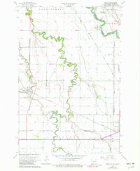
1964 Map of Dwight
USGS Topo · Published 1979About this map
The meandering Wild Rice River dominates this prairie landscape, carving deep oxbows through the townships of Dwight and Center. The geography is defined by its water and transport, with the river's path mirrored by the Chicago Milwaukee St Paul and Pacific and Great Northern railroads that intersect near the settlement of Dwight. This period of mid-century development shows a mix of spiritual and social hubs, including the Carmelite Monastery and several local burial grounds like Moore Cem and St Josephs Cem. To the east, the Red River forms the state line, where the outskirts of Wahpeton appear with a Sewage Disposal Pond and a Drive-In Theater, illustrating the expanding municipal footprint during the late 1970s updates. The map also captures smaller community landmarks such as the Townhall and the rail-stop at Brushvale near the confluence of Whisky Creek.
Find a feature on this map
24 named features on this map. Tap any name to fly to it.
Don’t see what you’re looking for? This feature index may not catch every label — zoom into the map to look around manually.
Map Details
Editions of this 1964 Dwight Map
3 editions found
Other maps of this area

1904 · Wahpeton
USGS Topo · 1:125,000

1953 · Fargo
USGS Topo · 1:250,000

1956 · Fargo
USGS Topo · 1:250,000

1960 · Galchutt
USGS Topo · 1:24,000

1960 · Mooreton East
USGS Topo · 1:24,000

1964 · Fairmount NW
USGS Topo · 1:24,000

1964 · Great Bend
USGS Topo · 1:24,000

1964 · Dwight
USGS Topo · 1:24,000

1964 · Wahpeton
USGS Topo · 1:24,000
1973 · Abercrombie
USGS Topo · 1:24,000