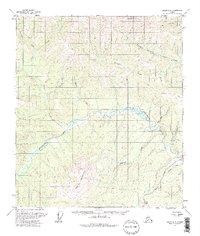
1957 Map of Eagle A-3
USGS Topo · Published 1975About this map
Taylor Mountain and Mount Wilson anchor the high ground in this mid-century look at interior Alaska’s gold country. The landscape is defined by the winding course of the Mosquito Fork Fortymile River, which gathers numerous tributaries named for the miners who prospected these valleys. The map documents a sparsely settled frontier where transportation relied on the Taylor Highway, supplemented by a network of Tractor Trails and Jeep Trails cutting through the brush. Evidence of early 20th-century industry and habitation appears as isolated Cabins, Ruins, and a Mine near Ingle Creek. These labels suggest a seasonal or transient footprint common to the Fortymile district during this era, where small-scale operations were scattered along drainages like Bullion Creek and Buckskin Creek.
Find a feature on this map
20 named features on this map. Tap any name to fly to it.
Don’t see what you’re looking for? This feature index may not catch every label — zoom into the map to look around manually.
Map Details
Editions of this 1957 Eagle A-3 Map
3 editions found
Other maps of this area

1899 · Fortymile
USGS Topo · 1:250,000

1949 · Tanacross
USGS Topo · 1:250,000

1950 · Tanacross
USGS Topo · 1:250,000

1951 · Eagle
USGS Topo · 1:250,000

1956 · Tanacross D-3
USGS Topo · 1:63,360

1956 · Tanacross D-2
USGS Topo · 1:63,360

1956 · Eagle B-2
USGS Topo · 1:63,360

1956 · Eagle A-2
USGS Topo · 1:63,360

1956 · Eagle B-3
USGS Topo · 1:63,360

1956 · Tanacross D-4
USGS Topo · 1:63,360