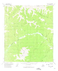
1957 Map of Eagle A-3
USGS Topo · Published 1975About this map
Taylor Mountain and Mount Warbelow anchor this subarctic landscape during the mid-1950s, a period when the Taylor Highway provided a vital corridor through the remote Yukon-Charley region. The terrain is defined by the complex drainage of the Fortymile River and its major tributary, the Mosquito Fork. The presence of a Mine near Ingle Creek and various Cabins along the watercourses points to the enduring legacy of placer mining and trapping in this district. Remnants of earlier activity are visible as Ruins situated near the confluence of Gold Creek and Buckskin Creek, offering a point of interest for researchers of early interior Alaska settlement. Primitive transport routes, including several stretches of Tractor Trail and a Jeep Trail, branch off the main highway toward remote claims and surveyor landmarks like VABM 2460 Road.
Find a feature on this map
26 named features on this map. Tap any name to fly to it.
Don’t see what you’re looking for? This feature index may not catch every label — zoom into the map to look around manually.
Map Details
Editions of this 1957 Eagle A-3 Map
3 editions found
Other maps of this area

1899 · Fortymile
USGS Topo · 1:250,000

1949 · Tanacross
USGS Topo · 1:250,000

1950 · Tanacross
USGS Topo · 1:250,000

1951 · Eagle
USGS Topo · 1:250,000

1956 · Tanacross D-3
USGS Topo · 1:63,360

1956 · Tanacross D-2
USGS Topo · 1:63,360

1956 · Eagle B-2
USGS Topo · 1:63,360

1956 · Eagle A-2
USGS Topo · 1:63,360

1956 · Eagle B-3
USGS Topo · 1:63,360

1956 · Tanacross D-4
USGS Topo · 1:63,360