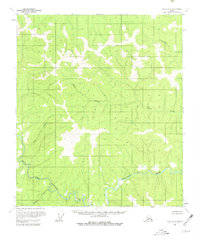
1956 Map of Eagle B-2
USGS Topo · Published 1980About this map
The Fortymile River and its North Fork dominate this mid-century topographic survey of the Alaskan interior near the Canadian border. The landscape reflects the area's gold-rush legacy, as shown by scattered remnants of habitation including Cabins, a lone Cabin, and a site simply marked as Ruins along the river banks. This survey, based on aerial photography from the 1950s, documents a wilderness still largely defined by its waterways. Sinuous drainage patterns are formed by Columbia Creek, Alder Creek, and Wilson Creek as they cut through the unnamed ridges. The absence of roads or established townships underscores the isolation of the Eagle B-2 quadrangle, where movement was dictated by the river valleys and the seasonal demands of mining and trapping.
Find a feature on this map
10 named features on this map. Tap any name to fly to it.
Don’t see what you’re looking for? This feature index may not catch every label — zoom into the map to look around manually.
Map Details
Editions of this 1956 Eagle B-2 Map
3 editions found
Other maps of this area

1899 · Fortymile
USGS Topo · 1:250,000

1951 · Eagle
USGS Topo · 1:250,000

1956 · Eagle C-1
USGS Topo · 1:63,360

1956 · Eagle C-2
USGS Topo · 1:63,360

1956 · Eagle A-1
USGS Topo · 1:63,360

1956 · Eagle B-2
USGS Topo · 1:63,360

1956 · Eagle A-2
USGS Topo · 1:63,360

1956 · Eagle B-1
USGS Topo · 1:63,360

1956 · Eagle B-3
USGS Topo · 1:63,360

1956 · Eagle C-3
USGS Topo · 1:63,360