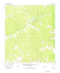
1956 Map of Eagle B-4
USGS Topo · Published 1976About this map
Fortymile River and its intricate drainage network dominate this mid-century survey of a remote interior landscape. The map details the confluence of the Middle Fork Fortymile River and several significant tributaries, including Portage Creek and Pittsburgh Creek. Unlike more developed regions, this area is defined by its watercourses and evocative topographical landmarks such as Manila. The survey represents a landscape largely untouched by permanent modern settlement, though the presence of Cabin (Ruins) near Fish Creek suggests the ephemeral nature of human activity in this terrain. The naming conventions, featuring labels like Chicago Boy Creek, Silver Bow Creek, and Gold Bottom Creek, point toward the area's prospecting and mining heritage. These family and descriptive names provide a geographical record of the individuals and ventures that navigated these forks during the mid-twentieth century, preserved just as aerial photogrammetry began to standardize the mapping of the Alaskan interior.
Find a feature on this map
23 named features on this map. Tap any name to fly to it.
Don’t see what you’re looking for? This feature index may not catch every label — zoom into the map to look around manually.
Map Details
Editions of this 1956 Eagle B-4 Map
2 editions found
Other maps of this area

1951 · Eagle
USGS Topo · 1:250,000

1956 · Eagle B-3
USGS Topo · 1:63,360

1956 · Eagle A-5
USGS Topo · 1:63,360

1956 · Eagle B-5
USGS Topo · 1:63,360

1956 · Eagle B-4
USGS Topo · 1:63,360

1956 · Eagle C-3
USGS Topo · 1:63,360

1956 · Eagle A-4
USGS Topo · 1:63,360

1956 · Eagle C-5
USGS Topo · 1:63,360
1956 · Eagle C-4
USGS Topo · 1:63,360
1957 · Eagle A-3
USGS Topo · 1:63,360