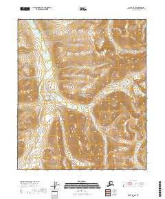
2018 Map of Eagle D-6 SW
USGS Topo · Published 2018About this map
Yukon-Charley Rivers National Preserve dominates the landscape of this interior Alaskan quadrangle, representing a massive stretch of protected wilderness. The drainage patterns are defined by the winding paths of Crescent Cr and its tributary Moraine Cr, which cut through the high-elevation terrain of the Yukon-Koyukuk region. This 2018 survey documents the intricate contour lines and topographic shifts of the land, providing a clear record of the watershed as it existed in the early 21st century. The map is primarily an environmental and topographic study, lacking roads or permanent settlements, which emphasizes the remote and undisturbed character of this portion of the preserve.
Find a feature on this map
10 named features on this map. Tap any name to fly to it.
Don’t see what you’re looking for? This feature index may not catch every label — zoom into the map to look around manually.
Map Details
Editions of this 2018 Eagle D-6 SW Map
This is the sole edition of this map. No revisions or reprints were ever made.
Other maps of this area

1950 · Big Delta
USGS Topo · 1:250,000

1951 · Big Delta
USGS Topo · 1:250,000

1951 · Eagle
USGS Topo · 1:250,000

1956 · Eagle C-6
USGS Topo · 1:63,360
1956 · Eagle D-6
USGS Topo · 1:63,360

1957 · Eagle
USGS Topo · 1:250,000

1958 · Big Delta D-1
USGS Topo · 1:63,360

1958 · Big Delta C-1
USGS Topo · 1:63,360

1958 · Big Delta
USGS Topo · 1:250,000
2018 · Big Delta D-1 NE
USGS Topo · 1:25,000