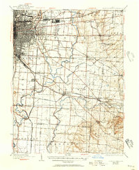
1925 Map of East Columbus
USGS Topo · Published 1957About this map
Columbus and its eastern suburbs are captured here at a moment of significant transit-oriented expansion during the 1920s. The landscape is defined by the converging paths of the Scioto River and Big Walnut Creek, where riverfront development like Steelton and agricultural hubs such as Canal Winchester and Groveport thrived. The map reveals an intricate infrastructure of early aviation and industry, including Norton Field and the expansive U S Army Supply Depot.
Find a feature on this map
66 named features on this map. Tap any name to fly to it.
Don’t see what you’re looking for? This feature index may not catch every label — zoom into the map to look around manually.
Map Details
Editions of this 1925 East Columbus Map
3 editions found

Other maps of this area

1901 · Dublin
USGS Topo · 1:62,500

1902 · Westerville
USGS Topo · 1:62,500

1903 · Dublin
USGS Topo · 1:62,500

1904 · Westerville
USGS Topo · 1:62,500

1907 · Lancaster
USGS Topo · 1:62,500

1907 · Thurston
USGS Topo · 1:62,500

1908 · Granville
USGS Topo · 1:62,500

1909 · Lancaster
USGS Topo · 1:62,500

1909 · Thurston
USGS Topo · 1:62,500

1910 · Granville
USGS Topo · 1:62,500