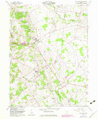
1961 Map of East Liberty
USGS Topo · Published 1983About this map
East Liberty and Middleburg anchor this rural landscape in Logan and Union Counties during the early 1960s, a period when small-town infrastructure remained clearly defined. The geography is marked by numerous family and community burial grounds, including the Quaker Cem, Hatcher Cem, and Inskeep Cem, which provide significant value for genealogical research. The transition of the local economy is visible in the transportation networks, where an Old Railroad Grade runs parallel to the modern Conrail line near a local Quarry. Beyond the village centers, the map documents a terrain defined by the drainage of Mill Creek and Otter Creek. Institutional landmarks such as the Zane Sch and the Landing Field near Middleburg reflect the civic life of these central Ohio townships as they appeared before modern agricultural consolidation.
Find a feature on this map
35 named features on this map. Tap any name to fly to it.
Don’t see what you’re looking for? This feature index may not catch every label — zoom into the map to look around manually.
Map Details
Editions of this 1961 East Liberty Map
4 editions found
Other maps of this area

1913 · East Liberty
USGS Topo · 1:62,500

1913 · Richwood
USGS Topo · 1:62,500

1914 · Mechanicsburg
USGS Topo · 1:62,500

1915 · Richwood
USGS Topo · 1:62,500

1915 · East Liberty
USGS Topo · 1:62,500

1916 · Mechanicsburg
USGS Topo · 1:62,500

1916 · Milford Center
USGS Topo · 1:62,500

1944 · East Liberty
USGS Topo · 1:62,500

1944 · Mechanicsburg
USGS Topo · 1:62,500

1944 · Richwood
USGS Topo · 1:62,500