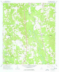
1965 Map of Eastabuchie
USGS Topo · Published 1978About this map
The Leaf River and Bowie River confluence defines this rural landscape on the border of Jones and Forrest counties. During the mid-1960s, the area maintained a distinct agricultural and small-town character, with the Southern railroad line serving as a primary corridor through Eastabuchie and Moselle. The map reveal a dense concentration of family and community heritage sites, including numerous small burial grounds like Callahan Cem and Edmonson Cem, alongside rural congregations at New Zion Ch and Pine Grove Ch. A notable modern addition to the landscape is the WDAM-TV Radio Tower near the river, while a Drag Strip in the southern section highlights the recreational culture of the era. The presence of Sandpits and Sandpit operations along the riverbanks points to the local extractive industry that shaped the river corridor.
Find a feature on this map
43 named features on this map. Tap any name to fly to it.
Don’t see what you’re looking for? This feature index may not catch every label — zoom into the map to look around manually.
Map Details
Editions of this 1965 Eastabuchie Map
4 editions found
Other maps of this area

1953 · Hattiesburg
USGS Topo · 1:250,000

1958 · Hattiesburg
USGS Topo · 1:250,000

1963 · Barrontown
USGS Topo · 1:24,000

1964 · Carterville
USGS Topo · 1:24,000

1964 · Seminary
USGS Topo · 1:24,000

1964 · Ellisville
USGS Topo · 1:24,000

1964 · Hattiesburg
USGS Topo · 1:24,000

1965 · Hattiesburg SW
USGS Topo · 1:24,000

1965 · Eastabuchie
USGS Topo · 1:24,000

1965 · Moselle
USGS Topo · 1:24,000