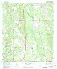
1965 Map of Eastabuchie
USGS Topo · Published 1982About this map
The meandering course of the Leaf River dictates the geography of this 1960s landscape, serving as a backdrop for numerous family cemeteries and country churches across the Jones Co Forrest Co border. Remote homesteads and rural communities are tied together by the Southern railroad and the Illinois Central line, which skirts the Bowie River in the southwestern corner near Rawls Springs. Local history is deeply embedded in the terrain through named sites like Old Leeville Cem and the Mary Magdalene Ch.
Find a feature on this map
44 named features on this map. Tap any name to fly to it.
Don’t see what you’re looking for? This feature index may not catch every label — zoom into the map to look around manually.
Map Details
Editions of this 1965 Eastabuchie Map
4 editions found
Other maps of this area

1953 · Hattiesburg
USGS Topo · 1:250,000

1958 · Hattiesburg
USGS Topo · 1:250,000

1963 · Barrontown
USGS Topo · 1:24,000

1964 · Carterville
USGS Topo · 1:24,000

1964 · Seminary
USGS Topo · 1:24,000

1964 · Ellisville
USGS Topo · 1:24,000

1964 · Hattiesburg
USGS Topo · 1:24,000

1965 · Hattiesburg SW
USGS Topo · 1:24,000

1965 · Eastabuchie
USGS Topo · 1:24,000

1965 · Moselle
USGS Topo · 1:24,000