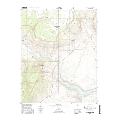
2017 Map of Echo Amphitheater
USGS Topo · Published 2017About this map
Echo Amphitheater serves as a central landmark in this rugged northern New Mexico landscape, where the high plateaus of Mesa de los Viejos and Mesa Prieta drop sharply toward the Rio Chama. The waterway feeds into the Abiquiu Reservoir at the southern edge of the survey, a critical water resource for the region. The map documents a land managed largely by federal agencies, split between the Carson National Forest and Santa Fe National Forest. Long-distance travelers can trace the path of the Continental Divide National Scenic Trail as it winds across the high ground, passing near a network of vital livestock and wildlife water sources including Joaquin Tank, Claverine Tank, and Madrid Tank. The elevation change is dramatic, moving from the river valley up through Joaquin Canyon to the extensive Mesa Alta highlands.
Find a feature on this map
29 named features on this map. Tap any name to fly to it.
Don’t see what you’re looking for? This feature index may not catch every label — zoom into the map to look around manually.
Map Details
Editions of this 2017 Echo Amphitheater Map
This is the sole edition of this map. No revisions or reprints were ever made.
Other maps of this area
1909 · Gallina
USGS Topo · 1:125,000
1918 · Abiquiu
USGS Topo · 1:125,000
1953 · Canones
USGS Topo · 1:24,000
1953 · Alire
USGS Topo · 1:24,000
1953 · Echo Ampitheater
USGS Topo · 1:24,000
1953 · Arroyo Del Agua
USGS Topo · 1:24,000
1953 · Canjilon
USGS Topo · 1:24,000
1953 · Laguna Peak
USGS Topo · 1:24,000
1953 · Navajo Peak
USGS Topo · 1:24,000
1953 · Youngsville
USGS Topo · 1:24,000