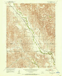
1951 Map of Eddyville SW
USGS Topo · Published 1953About this map
Eddyville sits at the edge of this prairie landscape in the early 1950s, serving as a hub for the surrounding agricultural townships. The Union Pacific railroad cuts diagonally across the terrain, paralleling the winding course of the Wood River. This transport corridor was vital for the regional economy, linking the rural districts of Loup and Kennebec to wider markets.
Find a feature on this map
9 named features on this map. Tap any name to fly to it.
Don’t see what you’re looking for? This feature index may not catch every label — zoom into the map to look around manually.
Map Details
Editions of this 1951 Eddyville SW Map
3 editions found
Other maps of this area

1896 · Lexington
USGS Topo · 1:125,000

1899 · Lexington
USGS Topo · 1:125,000

1951 · Eddyville NE
USGS Topo · 1:24,000

1951 · Eddyville NW
USGS Topo · 1:24,000

1951 · Oconto SE
USGS Topo · 1:24,000

1951 · Eddyville
USGS Topo · 1:24,000

1951 · Eddyville SW
USGS Topo · 1:24,000

1951 · Oconto
USGS Topo · 1:24,000

1955 · Broken Bow
USGS Topo · 1:250,000

1955 · Grand Island
USGS Topo · 1:250,000