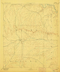
1896 Map of Eden
USGS Topo · Published 1906About this map
The Brady Mountains form a prominent east-west escarpment across this Texas landscape, surveyed just decades after the region was organized into formal counties. The settlement of Eden sits at a critical junction where trails from the north and west converge near the headwaters of Harden Branch and Brady Creek. This 1880s survey captures the early footprint of ranching life in the Edwards Plateau transition, showing a terrain deeply etched by seasonal watercourses like Kickapoo Creek and Mustang Creek. Farther east, the small community of Salt Gap marks a natural passage through the hills, serving as a landmark for travelers moving toward the Colorado River at the northern edge of the sheet. The drainage patterns of family-named creeks, such as Fitzgerald Creek and Reubels Creek, reflect the scattered settlement pattern of late 19th-century Concho and McCulloch counties before the arrival of major rail lines.
Find a feature on this map
28 named features on this map. Tap any name to fly to it.
Don’t see what you’re looking for? This feature index may not catch every label — zoom into the map to look around manually.
Map Details
Editions of this 1896 Eden Map
4 editions found

Other maps of this area

1887 · Mason
USGS Topo · 1:125,000

1887 · Coleman
USGS Topo · 1:125,000

1889 · Coleman
USGS Topo · 1:125,000

1891 · Hayrick
USGS Topo · 1:125,000

1892 · San Angelo
USGS Topo · 1:125,000

1892 · Eden
USGS Topo · 1:125,000

1892 · Ballinger
USGS Topo · 1:125,000

1893 · Fort McKavett
USGS Topo · 1:125,000

1894 · Brady
USGS Topo · 1:125,000

1894 · Hayrick
USGS Topo · 1:125,000