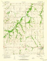
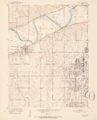
1956 Map of Edgerton
USGS Topo · Published 1958About this map
Edgerton stands as a focal point in the southeast corner of this mid-1950s landscape, serving as a hub for the Santa Fe railroad and local agriculture. The terrain is defined by the headwaters of Captain Creek and Wakarusa Creek, which carve winding paths through the townships of Palmyra, Eudora, and McCamish. A notable industrial footprint is visible in the northeast at the Sunflower Ordnance Works Reservation Boundary, marking the edge of a significant military-industrial installation. For local historians, the map preserves the locations of several rural institutions that anchored these farming communities, including the Round Oak Sch, Prairie Center Ch, and multiple burial grounds like the Old Black Jack Cem near the historic Black Jack settlement. The presence of a Compressor Station and Oil Tank near the town center indicates the mid-century energy infrastructure supporting the region.
Find a feature on this map
26 named features on this map. Tap any name to fly to it.
Don’t see what you’re looking for? This feature index may not catch every label — zoom into the map to look around manually.
Map Details
Editions of this 1956 Edgerton Map
3 editions found
Other maps of this area

1885 · Lawrence
USGS Topo · 1:125,000

1887 · Olathe
USGS Topo · 1:125,000

1889 · Lawrence
USGS Topo · 1:125,000

1893 · Olathe
USGS Topo · 1:125,000

1947 · Lawrence
USGS Topo · 1:250,000

1950 · Lawrence
USGS Topo · 1:250,000
1950 · Lawrence East
USGS Topo · 1:24,000

1951 · De Soto
USGS Topo · 1:24,000
1951 · Eudora
USGS Topo · 1:24,000

1956 · Wellsville
USGS Topo · 1:24,000