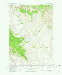
1957 Map of Edie Ranch
USGS Topo · Published 1961About this map
Beaverhead Mountains dominate this high-altitude landscape along the Idaho-Montana Boundary, where the Continental Divide separates the Beaverhead National Forest and the Targhee National Forest. The 1957 field check records a sparsely populated ranching and wilderness area, centered on the Edie Ranch and the vital waters of Medicine Lodge Creek. The terrain is defined by dramatic peaks and deep drainages, from the northern Red Conglomerate Peaks to the southern reaches of Black Mtn and Heart Mtn.
Find a feature on this map
60 named features on this map. Tap any name to fly to it.
Don’t see what you’re looking for? This feature index may not catch every label — zoom into the map to look around manually.
Map Details
Editions of this 1957 Edie Ranch Map
4 editions found
Other maps of this area

1955 · Dubois
USGS Topo · 1:250,000

1957 · Paul Reservoir
USGS Topo · 1:62,500

1957 · Scott Peak
USGS Topo · 1:62,500

1957 · Edie Ranch
USGS Topo · 1:62,500

1958 · Dubois
USGS Topo · 1:250,000

1964 · Small
USGS Topo · 1:24,000

1965 · Caboose Canyon
USGS Topo · 1:24,000

1965 · Gallagher Gulch
USGS Topo · 1:24,000

1965 · Lima Peaks
USGS Topo · 1:24,000

1968 · Snowline
USGS Topo · 1:24,000