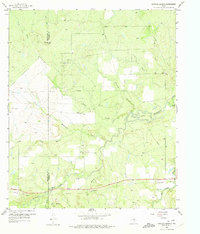
1958 Map of Edwards Branch
USGS Topo · Published 1974About this map
The border of Shackelford and Stephens counties bisects this West Texas landscape, defined by the winding course of Hubbard Creek. In the late 1950s, the area remained a patchwork of ranch land and industrial activity, characterized by numerous Oil Wells and a scattering of Sludge Pit and Gravel Pit operations. The drainage network is complex, featuring watercourses such as Mc Dowell Creek, Negro Creek, and South Branch, which converge toward the main creek valley.
Find a feature on this map
19 named features on this map. Tap any name to fly to it.
Don’t see what you’re looking for? This feature index may not catch every label — zoom into the map to look around manually.
Map Details
Editions of this 1958 Edwards Branch Map
3 editions found
Other maps of this area

1890 · Breckenridge
USGS Topo · 1:125,000

1892 · Albany
USGS Topo · 1:125,000

1893 · Albany
USGS Topo · 1:125,000

1954 · Abilene
USGS Topo · 1:250,000

1958 · Abilene
USGS Topo · 1:250,000

1958 · Breckenridge
USGS Topo · 1:24,000

1958 · Edwards Branch
USGS Topo · 1:24,000

1961 · Buck Mountain
USGS Topo · 1:24,000

1961 · Eolian
USGS Topo · 1:24,000

1965 · McCatherine Mountain
USGS Topo · 1:24,000