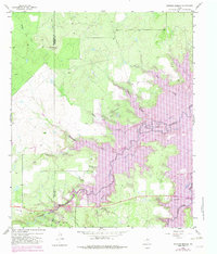
1958 Map of Edwards Branch
USGS Topo · Published 1982About this map
Hubbard Creek Lake dominates this landscape along the Shackelford and Stephens County line, reflecting a period of significant hydrological change in West Texas. While the original 1958 field data captured the natural meandering of Hubbard Creek and its many tributaries, later revisions shown in purple illustrate the inundation that created the reservoir, leaving high ground like The Island and Flat Top as prominent landmarks.
Find a feature on this map
21 named features on this map. Tap any name to fly to it.
Don’t see what you’re looking for? This feature index may not catch every label — zoom into the map to look around manually.
Map Details
Editions of this 1958 Edwards Branch Map
3 editions found
Other maps of this area

1890 · Breckenridge
USGS Topo · 1:125,000

1892 · Albany
USGS Topo · 1:125,000

1893 · Albany
USGS Topo · 1:125,000

1954 · Abilene
USGS Topo · 1:250,000

1958 · Abilene
USGS Topo · 1:250,000

1958 · Breckenridge
USGS Topo · 1:24,000

1958 · Edwards Branch
USGS Topo · 1:24,000

1961 · Buck Mountain
USGS Topo · 1:24,000

1961 · Eolian
USGS Topo · 1:24,000

1965 · McCatherine Mountain
USGS Topo · 1:24,000