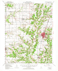
1950 Map of Effingham
USGS Topo · Published 1968About this map
The Little Wabash River and its tributaries carve a winding path through this central Illinois landscape, centered on the growing regional hub of Effingham. This 1950 survey documents a transition in transportation, showing the busy Pennsylvania and Illinois Central rail lines crossing near the city center alongside U. S. Highway 40. Local history is deeply etched into the rural townships, from the vanished river settlement of Funkhouser to the numerous country schoolhouses like Defiance Sch and Miller Chapel that once anchored these farming communities. Outside the main city, small villages such as Altamont, Watson, and Shumway maintain their distinct identities, while landmarks like the County Airport and Radio Tower WCRA signal the mid-century modernization of the county seat.
Find a feature on this map
91 named features on this map. Tap any name to fly to it.
Don’t see what you’re looking for? This feature index may not catch every label — zoom into the map to look around manually.
Map Details
Editions of this 1950 Effingham Map
4 editions found

Other maps of this area

1934 · Mattoon
USGS Topo · 1:62,500

1937 · Mattoon
USGS Topo · 1:62,500

1941 · St. Elmo
USGS Topo · 1:62,500

1942 · Shelbyville
USGS Topo · 1:62,500

1945 · St. Elmo
USGS Topo · 1:62,500

1945 · Kinmundy
USGS Topo · 1:62,500

1946 · Shelbyville
USGS Topo · 1:62,500

1947 · Kinmundy
USGS Topo · 1:62,500

1947 · Stewardson
USGS Topo · 1:62,500

1949 · Stewardson
USGS Topo · 1:62,500