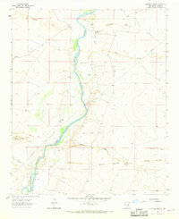
1962 Map of Eightmile Draw
USGS Topo · Published 1968About this map
Pecos River valley ranching and water management are the primary features of this mid-century New Mexico landscape. The map reveals a high concentration of established cattle operations along the river corridor and surrounding draws, including Neal Ranch, John White Ranch, and Circle 3 E Ranch. These ranching sites, alongside others like Sturgeon Ranch, represent the livestock-driven economy of Chaves County before significant modern development.
Find a feature on this map
33 named features on this map. Tap any name to fly to it.
Don’t see what you’re looking for? This feature index may not catch every label — zoom into the map to look around manually.
Map Details
Editions of this 1962 Eightmile Draw Map
3 editions found
Other maps of this area

1955 · Roswell
USGS Topo · 1:250,000

1958 · Roswell
USGS Topo · 1:250,000

1962 · Roswell
USGS Topo · 1:250,000

1962 · Eightmile Draw
USGS Topo · 1:24,000

1962 · Acme
USGS Topo · 1:24,000
1962 · Melena
USGS Topo · 1:24,000

1963 · Coyote Draw
USGS Topo · 1:24,000
1967 · Campbell
USGS Topo · 1:24,000

1967 · Haystack Mountain
USGS Topo · 1:24,000

1967 · Cottonwood Draw
USGS Topo · 1:24,000